In our previous articles about the amazing Exuma Island chain in the Bahamas, we stopped at 5 beautiful anchorages, discovered a submerged plane, enjoyed a dinghy ride through the mangroves, swam with the pigs, explored the grotto from the James Bond movie “Thunderball” and made new friends at the hospitable Black Point. Finally, it was the time to head back.
They say the way back is always faster than towards your destination. This is why we left something “for dessert”, to enjoy on the way home and break down our trip North. This was our last and possibly the most stunning anchorage in the Exumas.
Island 6 – Warderick Wells
Warderick Wells is the headquarters of the Exuma Land and Sea Park, a 176 square mile natural island and sea life preserve in the middle of the Exumas.

The Park has certain rules, such as no fishing, no lobstering and no collecting any sea or land life. There are multiple mooring fields and in order to protect the sea floor, cruisers are encouraged to use them. Both anchoring and mooring requires a nightly fee. At the main office credit cards are accepted but cash is preferred:
Nightly Mooring Rates (as for spring 2019)
- Up to 39’ 11” $20
- 40’ to 49’11” $30
- 50’ to 59’11” $40
- 60’ to 69’11” $60
- 70’ to 89’11” $90
Anchoring Rates:
- < 90’ $0.50 per foot
- 90’ and above $1.00 per foot
Warderick Wells Mooring Fields
The headquarters has two mooring fields: the main one, Warderick Wells or North Mooring Field, and the other one to the South, which is called Emerald Rock (thanks to a round green rock that towers right in the middle of the bay) or simply South Mooring Field. The Warderick Wells mooring field has an intricate entrance, where you have to fight strong currents, but it’s in the center of the action. The mooring balls are nestled in a deep and narrow channel, surrounding a beautiful white shoal. There is frequently a wait list for this field, so call in advance to reserve a spot.


Emerald Rock Mooring Field offers a lot more space and the approach is easy. You are surrounded by numerous beaches, hidden in small cuts and alcoves, and it is a short 5-minute dinghy ride to the headquarters.
We decided to stay at Emerald Rock due to space and easy access. It was also readily available. After we tied up our mooring lines and jumped into the turquoise water to cool off, our dinghy took us to the office.


The Sperm Whale
The office is a busy place, filled with tourists, cruisers and volunteers. Inside the building you will find a small display of the island’s ecosystem and some souvenirs. There is no Wifi available, but you can barely catch a bit of a signal outside at the corner of the building. You will quickly find where it is exactly, because there are always a couple of people standing with their phones in the air! 🙂


After paying our fees we took a short walk around. The first thing you see on the beach is a giant 53’ skeleton of a sperm whale. It died in 1995 after swallowing a plastic bag – a sad and silent reminder that plastic pollution of our oceans is not to be taken lightly.

Boo-Boo Hill
Warderick Wells has multiple walking and hiking trails, cutting through the island. The trails are marked with painted yellow arrows. Be prepared to jump from rock to rock and climb hills. One of the trails most taken leads to the legendary Boo-Boo Hill. It’s the tallest hill, surrounded by mangroves, and from the top you can see both the Atlantic and the banks at the same time.

The story goes that many years ago a ship crashed into a reef in this area during a storm. All the sailors perished and ever since their souls are haunting the hill and you can still hear their voices in the howling wind.
Nowadays, it is a tradition to leave something organic on the top of the hill with the name of your boat, as an offering to Neptune. Most people use driftwood, but you can see pieces of stone, teak, tile, shells and even a couple of boat parts.


We also left a little “souvenir”… Hope Neptune is kind to us on our way back!

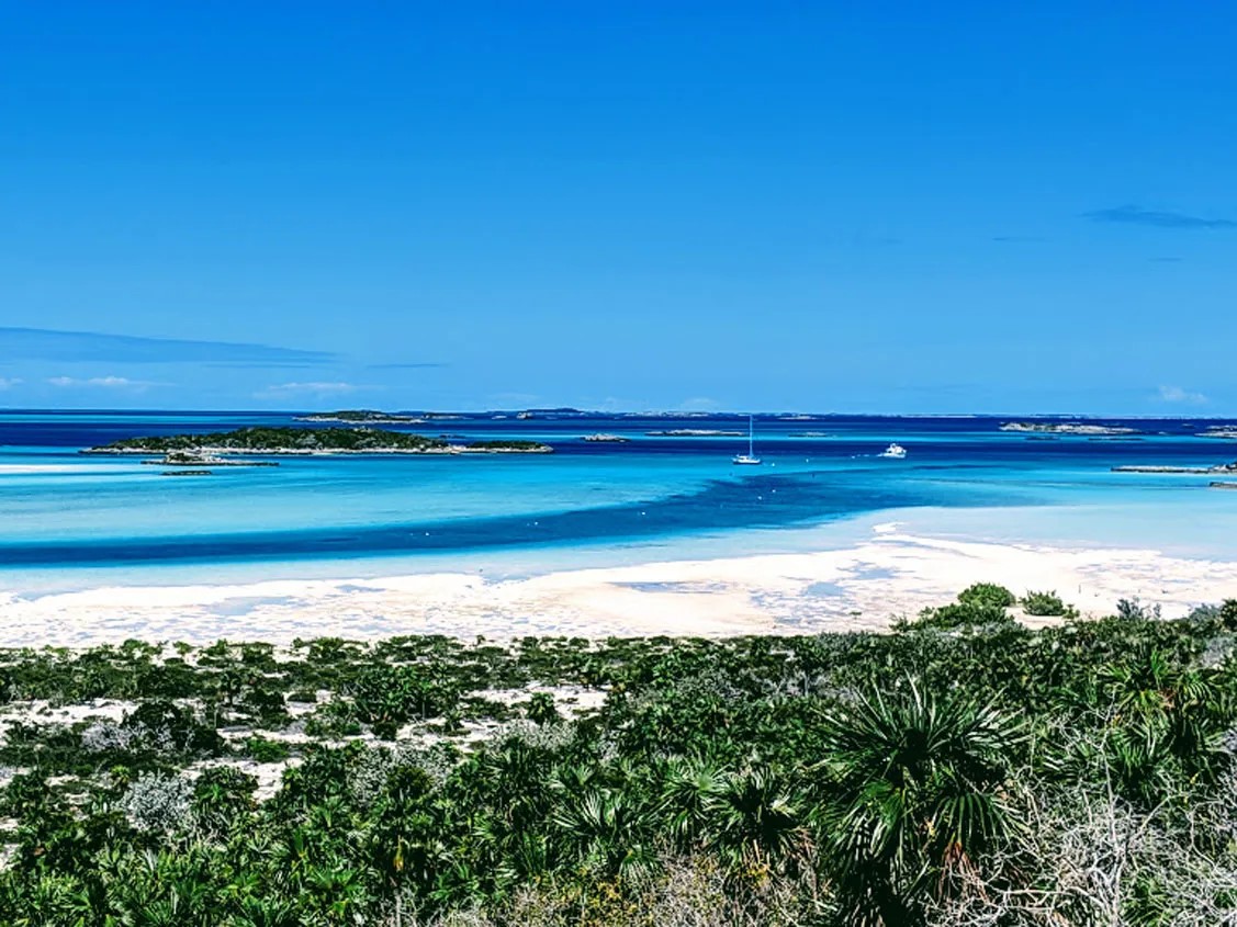
Sand and Water of Warderick Wells
Needless to say, we explored every little beach in the area. There are coral reefs all over the place and other snorkeling sites, and the office will provide you with a map of them as well as all of the hiking trails. The beauty of Warderick Wells is unique and absolutely mesmerizing due to numerous shoals and sand bars, jutting out in different directions through darker, deeper streaks of water, creating a stunning kaleidoscope of every shade of blue you can imagine. If you want a perfect picture of the Bahamas, I am convinced: you can take it right here at Warderick Wells.


The Way Back
The rest of our time was dedicated to coming back. We didn’t stay anywhere too long and sailed almost every day. No matter how much we wanted to stay and explore more islands, we had to go. We did stop in Nassau again to re-provision, before embarking on a three-day-long marathon to Bimini through Chub Cay and the banks.
Chub Cay was not particularly cruiser-friendly, so we didn’t go ashore and stayed on the boat. Early the next day we entered the banks through the Northwest Channel, where we kept listening to multiple sport fishing boats, boasting about their latest catch on VHF.

This time we didn’t go overnight. We stopped in the middle of the banks at a 10 ft. deep sandy area called Mackie Shoal. The holding was excellent, but the swell became unbearable by the morning. We left with the first light.
By the afternoon it became clear that rounding Bimini from the North was a bad idea. The wind blew close to 25-30 knots from the South. We decided to take the risk and sneak through the opening called Triangle Rocks, South of Bimini. For about ten minutes of this trip we were literally threading the needle, while passing through a shallow spot before Cat Cay. The tension was so high we were forgetting to breathe! The lowest depth on our depthfinder showed 6.3 ft. (our keel is 5.7)… Don’t repeat this at home! LOL When the depth finally started coming back and reached 14 ft., we burst into a happy dance, screaming with joy and high-fiveing each other. We went back into Bimini Sands Marina (now called Bimini Cove), which felt like home.
A couple of days later came the right weather window and there we were, flying on the waves again. With the Gulfstream pushing us from behind, our average speed was 8-9 knots, peaking at 12, so we successfully crossed 90 miles in less than one day. By 6 pm we dropped anchor in West Palm Beach.
How to Check In Back to the USA and Clear Customs – CBP ROAM
To check in, we used a phone app called CBP ROAM. In advance, even before leaving the United States, just download the app to your phone and create your account. You will have to input some information like your passport number and photos, as well as the information about your boat. Either before entering the inlet or after anchoring, simply declare your arrival – there is a big button for that.

An officer will request a video chat. He will verify your photos and voila! Welcome to the United States! The whole procedure was done right in the cockpit of our boat and took no more than 5 minutes. Extremely convenient and easy!
Conclusion
All in all, we spent 74 days in the Bahamas, from February 3rd to April 17th. The weather was really good, except only some days of Westerly winds and rough swells.
Winter storms were already over, and summer thunderstorms hadn’t yet begun. We really enjoyed this adventure and learned so much! Sitting at my computer and writing these lines, I am fiercely missing those gorgeous islands, pristine water and open and welcoming people. I hope we can go back to the Bahamas again soon!

Sailing Bahamas would not be possible without the Explorer Chartbook. Broken into three books with water resistant pages, it will make sailing Bahamas a lot easier and will save you tons of stress and possibly even prevent a disaster! Detailed charts, waypoints, latest depth soundings, loads of local information and advice. Really, this is a must-have for anyone who is sailing Bahamas.
Buy Explorer Charts on Amazon: